
Hike to Mjelkhaug
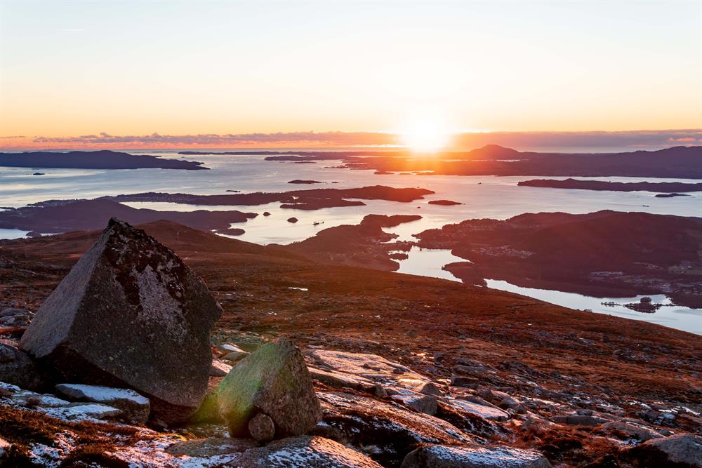
Location Husnes Overview Follow the path to the left (northeast) from the parking lot. There is eventually a somewhat steep incline up the Undarheimslia to 600m AMSL, where the terrain flattens before another ste...
Contact information

About
Location
Husnes
Overview
Follow the path to the left (northeast) from the parking lot. There is eventually a somewhat steep incline up the Undarheimslia to 600m AMSL, where the terrain flattens before another steep incline up to Mjelkhaug. There is a view of large parts of Sunnhordland, including the ocean and fjord towards the south and west. Manen, Englafjell and the Rosendal mountains towards the north. Ulvanosa towards the east.
Map
Folgefonna National Park
Start and stopping point
The parking lot by highway 48 right across Hellandsbrua bridge, by the information board for Husnes.
Parking
By highway 48 right across Hellandsbrua bridge, by the information board for Husnes. Please be cautious, this is a dangerous intersection.
Marking
Information Board by the starting point.
T markings and signs.
Grading
Red
Challenging hike, four boots according to the DNT system.
Difference in altitude
25 - 1005m AMSL
Estimated time
4 hours round trip
Recommended advice
From the top, one should go to the Mjelkhaugsteinen rock which is located approx. 300 meters east of the cairn. The rock is visible from the ocean and in old times was used as a sailing marker. It is approx. 12 meters long, 7 meters wide, and 7 meters tall.
An alternative return can be down over Svaneheia to the Varhaugselet mountain farm, and via Nordfjell back to the parking lot. See also the routes from Valen; use your imagination to create round trips.
It is reckoned that the sturdy farmhouse walls were erected in approximately 1860, and that the farm was in use until 1905. The restoration has been performed by ”Interesselaget for Varhaugselet” (Volunteer Organization to preserve the Varhaugselet), and the mountain farm is open for everyone all year round.